It started with an invitation to the wedding of my nephew. The Charleston clan gathering in Balgowan in the KZN Midlands in December 2015.
There’s got to be some opportunities in there for a ride or two. Lesotho’s on the way to KZN isn’t it?

I’d been wanting to get back into Lesotho – Matabeng pass was unfinished business. On the trip with Geoff Russel in March 2013, I’d hit a pothole and bent the torsion bar and had the indignity of riding over the pass in the backup vehicle – watching my Lady and Junaid’s dance a duet on the trailer.
An email to my Brother-In-Law – “How about meeting me in Matatiele? A quick trip over Matabeng pass and overnight at Sani. Perhaps we can fit in Bezuidenhout’s while we’re in KZN”. It’s on.
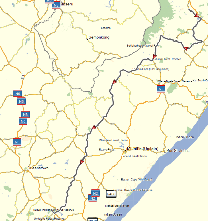
So Matatiele’s plugged into the diary. Now, there’s an awful lot of tar twixt Cape Town and there – what can we do about that? There’s a lot of the Eastern-Cape I hadn’t ridden either – seems like a perfect opportunity to turn a wedding invitation into a really good adventure …
Some googling of “Eastern Cape Passes” reveals something the 4×4 community call the “Big 8” or the “8 passes challenge” … sounds ideal. Let’s see how many of those I can pack in my bag.
But what about the return trip – that’s also quite a stretch? Hogsback looks like a nice place to visit – maybe have a looksee at Michel’s and Katberg passes.
So after much plotting and routing, and backup plans and alternate routes – all safely copied to my laptop as well.
I think Robbie Trygve’s Mountain Passes of South Africa is a brilliant site. I used it extensively in making my plans. Greg Beadle’s “Bike Tar and Gravel Adventures in South Africa” is also a useful (if sometimes incorrect) resource. After reading up a bit more on some of the passes, I’d resolved not to tackle Bastersvoetpad, Michel’s or Katberg alone – but I’d “have a looksee”.
10 days out from the trip and the weather looked awful – solid rain. Might be wearing out the tyres on tar all the way. Fortunately the closer it came to leave, the better the long-term forecast looked. In the end, there was only one day that was really mucky.
Day 1: Cape Town to Aliwal North (1040km) – Iron Butt award nominee.
Slab. Hot, windy, boring slab. R62 through to Oudtshoorn. Willowmore, Graaf Reinet, Middelburg, Aliwal North.
Temperatures from Willowmore to the end never dropped below 36°C. In Middelburg they reached 41.5°.
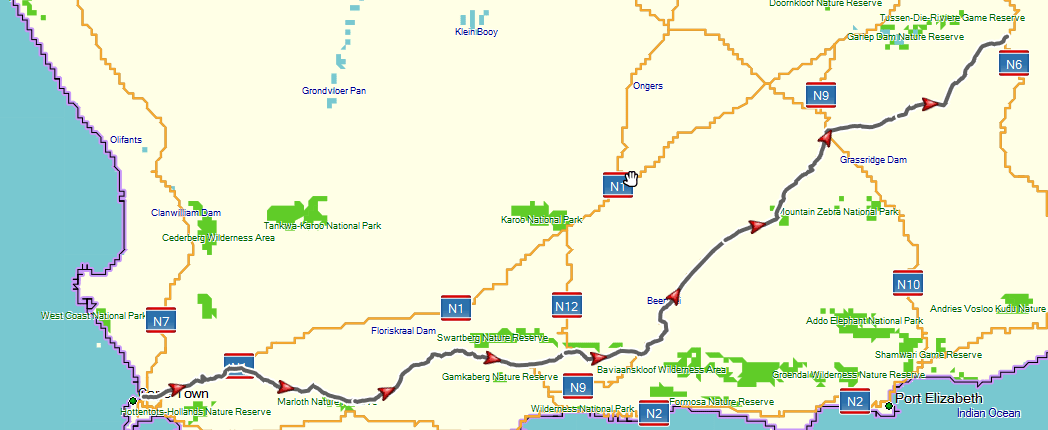
One major oops: I’d copied the GPS routes to my laptop but stupidly forgotten to copy them to the GPS itself. No worries I thought – that’s why I copied to the laptop. I’d also not updated the Tracks4Africa maps on my laptop though – so was bedevilled with map-version related routing gremlins for the rest of the trip. This was to bite me quite hard later. But it did seem a bit odd that the GPS was telling me I had another 1500km to go on leaving Diesel and Creme in Barrydale.

My Lady achieved the 100,000km just before Ladismith.
Overnight at “The Nest” guesthouse. Comfortable, well equipped (except for power – Eskom problem) and with a decent breakfast.
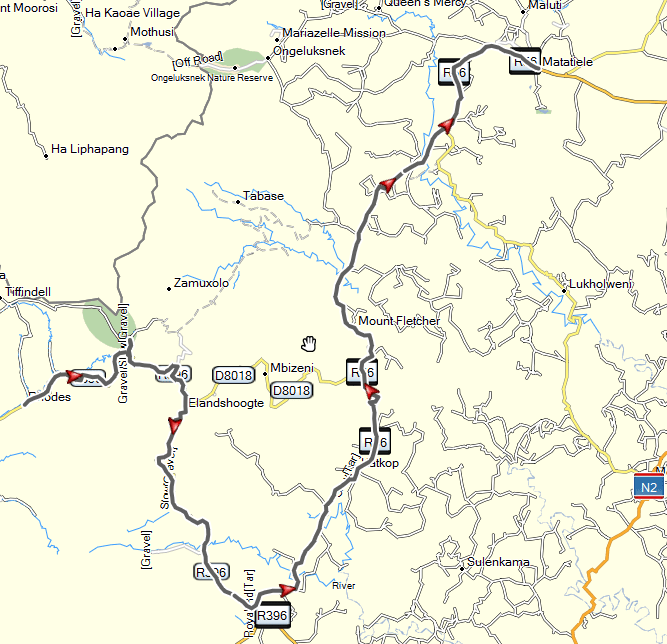
Day 2: Aliwal North to Rhodes – Beautifully Grey
The day started with grey skies, the weather reports were quite mixed – so I was going to play today according to the local weather around me.
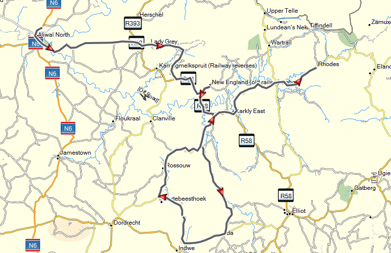
On to a grey Lady Grey (spent the rest of the day trying to remember what the song was) and Joubert Pass.

Jouberts Pass is fairly easy going most of the way up, possibly not for rank beginners – but nothing serious. A couple of short loose sections, but an easy start to the day. The road descends the other side into a lovely valley with farmland and game farms.
I’d give Joubert’s pass a 4/10 for difficulty.
The gravel road ends in a T-junction with a really good tar road. I rode this all the way through from Lady-Grey to Elliot the next day – a couple of minor potholes, but a really good and picturesque road. I’ve been critical of Eastern Cape roads in the past – but they also have some truly good ones, and some pretty awesome gravel passes too.

The weather cleared up at the top as I approached Barkly East. I’d originally planned to first drop down through Roussouw and Barkersnek pass, down to Indwe, and then later in the day to come back up to Rhodes via Otto Du Plessis pass. But the weather was clear, so I took the opportunity to reverse that and tackle the potentially more tricky pass first.

Perhaps approaching from the top doesn’t do it justice, and working your way up from the bottom is better; but I was a little disappointed. The road to the top winds through attractive scenery, but the sudden arrival at the top seemed too quick and unsatisfying. The view is certainly spectacular.

The gravel surface was pretty good going down, offering little serious challenge. One 500m stretch of rough and loose rock, with a couple of obvious rockfalls was the only real excitement. From the bottom of the pass to the next intersection of any seriousness, the road winds through farmlands – over some really rough farm roads. Washed away in several places – in some patches this was worse than the pass itself.

I’d give Otto Du Plessis pass a 5/10 in the dry.
Back up Barkersnek and through Rouussouw – some nice but very dry country. Roads mostly in pretty good shape. Approaching Barkley East I thought I was going to get some heavy rain – the skies were quite black, but they scurried over quite quickly, leaving the day grey like it started.

Barkly East through to Rhodes on some good solid secondary gravel roads. This is really beautiful country.
Stayed at Walkerbouts that night and the next. A bit old-fashioned but comfortable enough. A little bit pricey, but it was just about the only place open in Rhodes. The food was excellent though – which makes up for a lot.

I was just about the only visitor in Rhodes that night it seems, there was another solo traveller the next night. A quiet town.
2 of “The Big 8” were in the bag.
I had some bad news that evening – my BIL had arrived back from working in Ethiopia the day before (Friday), to find his bikes’ license had expired 2 months ago. And the JHB municipal offices and JMPD were on strike. He was going to try and get it sorted out before coming down on the Monday morning – but wasn’t willing to go into Lesotho on an expired license.
Day 3: Rhodes to Rhodes – I did fall
The sky was blue – no rain forecast, a beautiful day to tackle some passes.
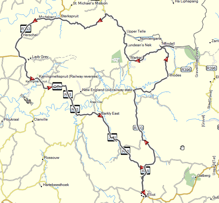
Carlilsehoek pass is the most frequently used route to Tiffindel. It’s partly paved in concrete – otherwise it would be quite difficult. Very steep and twisty, with some really tight bends. A normal car can manage this in good weather and with careful drivng – so it doesn’t really pose much of a challenge on a day like today. So, perhaps not for complete beginners. And could be a real handful in the wet.
Carlislehoek: 4/10.

Tiffindel was empty. No visitors. A nice lady made me a cup of coffee anyway though, and after a brief chat (I never manage long chats) I was on my way again.

I’d planned to try and get across to Tenahead lodge before coming to Tiffindel – but I’d missed the turn. I went back though. Apparently this becomes a really stunning ride along the Lesotho border. I only managed to get a third of the way before reaching a closed gate that said ‘private property’. Up to this point, the twee-spoor had been very rough – and it didn’t look like it was going to get any easier. I had a long day planned, and was running behind on time. I’d also come down a couple of very steep, loose and rocky section and was quietly thinking to myself “Oo-err” that’s going to be a handful going back. So I turned back.

No, I’m not a believer in the power of intentional thinking – but sometimes the niggling negative thoughts can interrupt my concentration. I’m not sure what I hit – my head was up, I was standing well and looking at the top of the slope, my speed was good – but the front bounced up and left and I went down and right, the top right of the windscreen smacking me in the left hand side of my chest.

These are the times I start to wonder if I’ve finally done it. Is this the end of my trip, only on day 3?
She’d dropped akwardly across the tracks – not ideal for picking up. The clips at the bottom of the windscreen were broken, so it was a bit floppy and loose. Caught my breath, rubbed my chest (a lot), drank some water and ate a snack-bar. Dragged her round so she was pointing up the slope and picked her up. Cleared a couple of loose rocks on the path and started off again.

Screamed “F*** Yeah!” when I got to the top of the slope and slowly made my way back over to the Wartrail road.
Tiffindel to Tenahead: 8/10 (my ribs demanded no less).
There’s a nice little dam at the top after the Tiffindel turnoff. The road along the top is rough but not bad. Relatively easy going – with stunning views down on the left. It wanders along the top for about 15km before coming to the start (or end if you’re ascending) the Volunteershoek (or Bidstone) Pass.

Looking back I saw a sign saying “The worst is over”. Hmmn, I think that for me it means !Xie !Xo !Xak going in my direction. It wasn’t so bad – but I’m not sure I’d be saying that if I’d been riding up. There are a couple of sharp bends, but the road is very steep, and very loose and rocky, and plenty of recent rockfalls to meander around.
As I was bumbling slowly down I was thinking that this is one hill where Tony Schlee would actually have to exercise his right foot and apply some rear brake. Mine was working overtime.

Without going back up, it’s impossible to know – but part of me was quite relieved I was going down. I think I prefer down to up – the bike has momentum which can be more easily controlled. Going up requires more throttle and clutch – and I sometimes find myself without enough momentum and then stalling. I’ll just have to go back sometime.
Volunteershoek: 7/10.
I followed the road round to the right, into the Wartrail valley heading for Lundean’s Nek. Stunning scenery all the way.
The road up to Lundean’s Nek from Wartrail is easy – nothing really exciting. There’s a military checkpoint near the top – you have to sign in. Apparently this is an area of significant cross-border stock-theft happens, and Lundean’s Neck provides a perfect lookout spot.
You get to the top quite quickly after the checkpoint, which is quite disappointing – loose cobbles in the road making it a little interesting.

The descent down the other side, to Upper Tele. is really worth it though for the views. Not really difficult, just a couple of loose patches and a couple of rockfalls. Again, I think this is a pass that would be better ridden the other way – more dramatic to struggle a bit to reach the top.

I’d originally planned to ride a loop around a couple of interesting looking roads, fill up in Sterkspruit and go back up Lundean’s Neck to Rhodes. But the weather report for the following day was looking a bit iffy – and I wanted to see if I could squeeze in another of the “8”.
Lundeans Nek: 5/10.
There’s a number of little roads that look worth exploring in this region. I took the Dr08606 across to SterkSpruit and pumped my tyres.
One of the “Big 8” is the Barkly Pass – a tar pass. A bit of an anomaly there – perhaps these 4×4 types are going soft. But as I mentioned before, it’s a beautiful road through from Lady Grey, via Barkly East, and then down the Barkly pass into Elliot. The tar was in good condition, the roads relatively clear, and a sweeping and swooping fast ride was a nice day to bag another.
Barkly pass: 0/10 for difficulty. 9/10 for fun.
The ride back from Elliot to Rhodes starts just opposite the Mountain Shadows hotel, which is also the road to Bastersvoetpad. It was late though, and light was starting to go, so I just blasted past on some more fantastic gravel roads back to Rhodes.

I’d spent the day mulling over my options if the BIL didn’t make it to Matatiele. Went to bed still mulling.
Day 4: Rhodes to Matatiele. Surprisingly, I did not fall in the mud.
Awoke to very grey skies. Weather report was not promising. Or rather, it was promising rain after 09h00.
I’d been planning to go up over Naude’s Nek and then loop back and around over a couple of smaller passes. So I headed out anyway. Half way up I stopped to put on my rain-frighteners. They didn’t work.

As I wound my way around to the top it was getting mistier and murkier. I hate mist – because my visor starts to bead up, so I open it a bit to see more clearly and then my glasses start to bead up – it’s much easier if it rains big drops. Visibility at the top was down to about 20m.
I decided to turn off to Tenaheads and ask (a) for a cup of coffee, and (b) if they had any idea what the weather was like on the other side. Wet they said. But the coffee was welcome.

As I arrived there was a couple of other bikers preparing to leave.
They’d started out from Zastron the previous day, up Lundeans, up Volunteershoek and across to Tenaheads from Tiffendel. They’d originally planned to carry on down Naude’s Nek and end up in Ugie. And there I though that some of my plans were a bit ambitious …
They’d come a cropper on the same path I had – and struggled to pick up the Triumph 800. Then it got a puncture – which they battled to get repaired. Apparently they’d finally arrived at Tenaheads in the dark after 21h00.
They kindly agreed to let me follow them down the mountain – they were still heading for Maclear and on to Ugie. Leaving Tenaheads it started to hail. But it was not hard ice though – quite soft, like being bombarded with hundreds of small slush-balls. Weird.

Back on the pass and we went slowly down. At first the road was rocky and not too wet. Just went down slowly and carefully. We descended through the mist, and the road became less rocky and the couds started lifting. The mist turned to rain, and the roads turned to mud. It was beautiful and green – but the mud was vicious.
I don’t like mud. I’m not sure if I paddle more in mud than I do in sand – but I paddle plenty.

One of the other fellas, the least experienced on the new GS 800 adventure struggled far more than I did. 5 times he fell. Each time getting more and more distressed at his failure to negotiate the muck; and steadily losing more and more of his bike as he went.
We passed a group of 3 GSA riders and pillions. How anyone can choose to pillion on a dry day baffles me. On a day like today – I’d be f*****g terrified as either pillion-ed or pillion-er.

Finally made it down to Maclear and I said Thanx’nBai and headed off on tar towards Matatiele. No further thoughts of riding sludge that day.
It’s hard to put a difficulty number on Naude’s Nek. In the mud it was 9/10 – but I’d guess only 5/10 in the dry.
Vincent (BIL) had left messages to say he definitely wasn’t going to be able to make it. He’d found out that the Post Office was now doing License Renewals but they had been doing a software upgrade that Monday and would only be able to help him tomorrow. He’d try and meet me at Sani Top tomorrow evening.
Stayed at Resthaven in Matatiele (we’d stayed there before with Geoff). It’s still a good spot. I had resolved to tackle Lesotho on my own if: (a) it stopped raining, (b) Phillip, Resthaven’s owner and someone who knows something of the roads, knew of no problems on the planned route.
The weather report for Tuesday was looking good. Phillip knew no impediments, knew of no likely flooded river crossings, and said the roads would be dry within 2 hours of sunrise. I fired off an email and SMS to my ICE contacts with a set of instructions, apologised in advance for the deluge of SPOT check-ins I’d be doing, and girded my loins.
Day 5: Matatiele to Sani Top, over Matabeng pass. Solitary bliss.
The skies were clear that morning. The roads already drying as I left at 07h15. This was going to be a long, and potentially arduous day in the saddle. I was feeling in great shape.
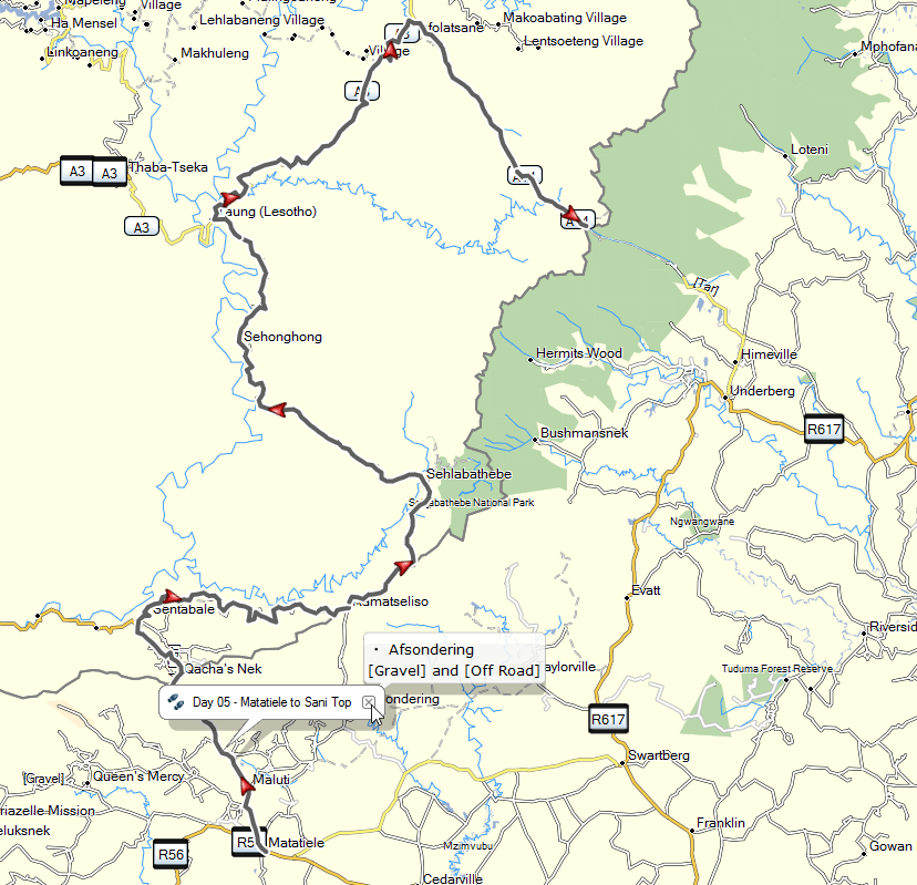
Because of my GPS map and routing difficulties, I’d set my destination to Ramatseliso’s Gate; and was following that. The route looked oddly unfamiliar as I rode – but I put that down to the fact I’d been in the back of a bakkie last time. Until I arrived at Quache’s Nek border post that is. The f*****g GPS had waylaid me.

I thought of turning around and taking getting to the ‘right’ border post – but a quick look at the map reminded me that the A4 runs along the border from Quache’s Nek to Ramatseliso – the GPS had merely picked that as the shortest route. I’ll carry on then!
C’est la vie – no harm done Or was there? I’d forgotten that distance in Lesotho is measured in time and not in Km. That short stretch of the A4 took me about 75 minutes. I think it would have taken less than half that time if I’d gone back and taken an SA road to Rama’s gate.
So I’m already an hour behind on a long day. But: What the Heck. I’m in Lesotho – I’m riding some interesting roads. Life is Good.

I reach Sehlabathebe in good time, miss the turn off and have to turn back after a couple of kms.
But then the ‘road’ disappears into an absolute wasteland of rocks and rubble. Surely this can’t be right? I stop, dig out the map, double check everything and reassure myself. Yes – this myriad of goat tracks and rocks does appear to be the right way. I really don’t remember this part from the backup-vehicle ride.
The tweespoor improves and heads up the mountain in a vague direction that seems to fit my memories. I can finally make out the radio tower at the top. Yup, I’m definitely on the right track.

I work my way up to the top, stopping for a breather every now and then. Yeeehah! I’m on top of the world and completely alone.

The trip down the other side is similar, rocky and loose sections, parts of the road washed away. Softly softly, pick a line and commit. Breathe. Damn! This is awesome fun, certainly not a normal day in front of a PC.
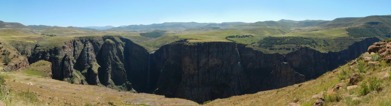
I’d been concerned about the section of road beyond the pass – coming down to the ‘picnic area’. It’s hard to describe it any other way, in the middle of this valley, with rocky and rugged roads on either side – there’s this place with trees (an unusual sight in Lesotho) alongside a rocky river bed, with green grass.
Previously it had been bad, and Geoff had warned me about this section. It wasn’t as bad as I’d remembered, so reaching the picnic-spot was quite a relief.

The road through to Sehonghong is in pretty good shape and I made good time. On to Taung and the turn off onto the A3.

I’d been warned this road was in bad shape, and that the building of a new dam had meant that trucks had wrecked it.
Initially that seemed misplaced, the gravel road was clearly recently rehabilitated. Until I reached the steeper sections that is – here the roadworks are not only ‘in progress’, but the road is in a really poor state. Piles of loose rocks in the road itself, obviously for the rehabilitation – but almost without regard for placement. These don’t appear to be Chinese roads either – the dump trucks do not give a s**t for anyone – let alone motorcycles. Further on, there are a couple of really rough sections of steep pass – some parts rivalling Matabeng pass itself for toughness.

It was a pleasure to finally reach St. James and the new ‘Chinese’ tar road. Right now, this is a work of art. I’d travelled it a year before and was very critical of the building methods. It cleans up real nice.
The road surface itself is excellent, road markings good, but the route it takes follows the contours – twisty and windy and magnificent. But: speed is restricted to 50km on most parts. And just because it is a tar road does not mean it isn’t well travelled by animals. There’s plenty of donkey-poop on it already. As it passes through villages, there are further speed restrictions and speed-humps.

It would be interesting to follow it all the way North – now, while it is still in good shape. I’m not sure how long it will hold up after a couple of years of bad weather.
Sani Top arrived swiftly and a Maluti was devoured at speed. For a moment I thought I’d left my wallet at Quache’s Nek – must have looked demented, patting every pocket I could find. There are way too many pockets in Motorcycling gear for an aging mind …

Vincent arrived about 40 minutes later. We stayed over at the backpacker’s – the prices for the normal rooms were a bit steep. The backpackers is basic, but passable.
Two other bikers joined us at the backpackers (as well as a couple of other tourists put off by the high prices of rooms at the inn). They’d followed pretty much the same route I had – although they had started in Maclear that morning and not in Matatiele. One of them is working his way around the 4 corners – you can read about it on WildDogs….
Matabeng pass is definitely not for novice riders. There are some very rocky and loose sections, but it is also not a seriously difficult pass. The pass itself probably is only a 6/10. The challenge is that it is in the middle of nowhere – it’s a long ride to get to any place of substance.
As a whole, I’d give the day a 8.5/10 for endurance combined with difficulty. I was a very happy (and knackered) man going to bed that night.
Day 6: Sani Top to Balgowan. And Piggly Wigglys.
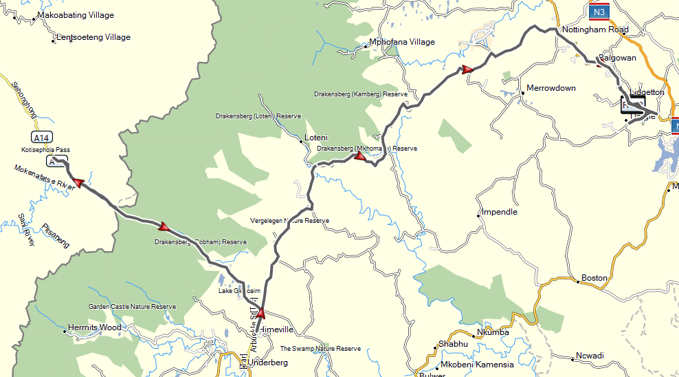
This was a relatively easy day, starting with breakfast at Sani top. And then a quick trip back up to the top of the Thaba Potsoa pass on the new tar, so Vincent could experience the new road. The last time we’d been up there it had been quite muddy. Red Bull really need to come up here for their downhill skateboarding competition – the road is beautiful, twisty and steep.

Out through the Lesotho border post and down the pass. I’d only ever ridden up Sani Pass before, both times struggling a little with momentum around the steep and rocky corners – stalling on a rough corner both times. Coming down was much easier this time, there’s always momentum – just let the clutch out a little. Sani pass that day was only 5/10.

The pass was relatively quiet at the top, but it was December the 16th and as we neared the bottom, there was a stream of them heading up hill. There was a queue at the border post for those heading up, but nothing for us entering SA. The lower stretches, heading away from the border post were the riskiest section that day – some real boorish and idiotic driving from those tearing uphill.

Then a nice quiet ride around some lovely twisty gravel and tar on the P27-3 through to Nottingham Road.
A stop at Piggly-Wigglys for lunch and a brief thunderstorm. After the rain had cleared we headed back to Balgowan to join the rest of the family at our stay for the next 5 days: Beacon Vlei dam.
Beacon Vlei is a nice place, a group of self-catering cottages right on the vlei. There are a couple of fish eagles to wake you up in the morning.

Day 7: Pinetown and back. Windscreen repairs.
A quiet day, getting some washing done – and a quick trip through to Ryder Motorrad in Pinetown to see if I could get some new clips to fix my windscreen. Friendly service from Alex, who used to work at Atlantic Motorrad in Cape Town – he refused to let me leave on my very grubby steed and had it washed.
Day 8: Valley of 1000 Hills, and 1000% humidity
There are some days where things do not go as planned. I like to look back on them as ‘great-learning-experiences’ rather than ‘should-not-be-mentioned-ever-again’. The idea had been to take a ride out around the Valley of a Thousand Hills – and I’d ‘borrowed’ the route from Dual Sport Africa.
The route did not download properly for some reason, and it wouldn’t load on Vincent’s GPS properly either. I took a stab at ‘fixing’ it on my laptop, and managed to get something loaded on both that looked reasonable.
Now this is the day I learned the hard way about Rule 13: “Take a map”. We set out on a warm morning, headed for Pietermaritzburg and all of those hills. Things started to a little awry as we stumbled through an industrial section, GPS pointing us down lots of dead ends.

Finally made it out onto the P26 and around Nagle Dam. The day was heating up fast, and Vincent was starting to run out of fuel. I’d not really planned well enough for his smaller tank, and all of the unexpected fumbling around getting lost.
Ok, I say – we have this marvellous GPS thingy that tells me the nearest place to get fuel – let’s abandon the route, find fuel and beer and head back for a cold shower. Mistake a deux.
Unless you have a really, really good idea of where you are, and where the GPS is taking you – that 12km to nearest fuel may be the longest 12km you will ever travel; and the valley of 1000 hills also is a valley of 1000 little roads.
At some point the GPS was telling me I should be driving down the middle of the river bed, and then through some of the thickets shrubbery in KZN. No problem says Vincent – my GPS says we should go up this road. I follow, and then up this steep and rutted road I slip into a nasty little sloot.

Vincent had torn up the hill and was off around the corner. I tried to get the bike up and out, but the back wheel was spinning and I could start to smell the clutch. No cellphone reception. And by now it was mid-day and really hot and humid. The temperature gauge was showing 38 degrees – but it felt like 90.
So I took off my kit and tried to pack stones in behind the back wheel. What an effort that was – search around for a stone, pack it in – and then fall into the shade panting like a madman and rest for 5 minutes to recover. Finally manage to pack in enough stones and get the bike moving up and out – only to fall into the next sloot 2m up ahead.
Same, slow, hot, sweaty procedure. Now I’m starting to worry about Vincent, it’s been 45 minutes and he hasn’t come back to look for me. Manage to get enough stones packed in and try again – another metre – another sloot. Another 15 minutes in the shade trying to recover.
At this point well over an hour and no sign of Vincent. Press the ‘Help’ button on the SPOT device to signal to my sister Katrina that I was in trouble [not the send-out-the-choppers button though]. By now a couple of small kids had arrived.
They must have thought I was mad – because by then I’d had enough. Opened up the top-box and got out the tow ropes. Pushed the bike over on its side with the wheels clear of the ruts.

Dragged it around with the towrope so it was pointing back down hill. Have major palpitations and lie under a tree for a bit. Pick the bike up. Another lie-down needed. Finally get on the bike and down the hill.
Another lie-down to recover, but I’ve left my kit half-way up the hill. Wave a R50- note at the kids and beckon them to bring my jacket and helmet down – cheap at the price …
Use SPOT to send an I’m Ok message, part of a prearranged signal that I’d managed to recover the situation and was on the move. Get back on the bike and head out the way we’d come and reached a shady spot where there was cellphone signal. My hands are shaking violently – drink water, use an emergency-kit glucose sachet – don’t feel like eating but force myself to have a little biltong too. Call Katrina – they are on their way. Vincent had managed to call them – using his “English” cellphone, his SA one also had no signal.
He’d also gotten stuck in a rut – just about 750m further up the hill than I had. They hadn’t heard from him again. Their only GPS was Google Maps. Although I have signal, I have no 3G – and no Google Maps. So I backtrack further until I find 3G. Load Google Maps and send a location point at a decent road junction to Katrina. “Meet me here – then we’ll go back and find Vincent”. 15 minutes later, Vincent arrived at that same junction – looking knackered. He’d managed to recover his bike using the same method – push it over, drag it around, have a heart attack, pick it up and away …
I’d already reconnoitered a bit further up the road to find the ‘right’ way to the nearest town – so we called Katrina and asked them to meet us in Wartburg instead.
What a day, and there was still the groom’s dinner that night …

Apart from taking a paper map next time, and doing a far better job of planning the route for smaller bikes and unexpected diversions – I’d also forgotten one of the key things when needing more traction. Let down the tyres even more. I always carry a compressor, so it was a bit silly to not at least try dropping the pressure really low to try and get a bit more grip. Sometimes I get so focused on trying to get up and out that I forget the basics.
Day 9: Wedding day. Guess I can’t ride then.

Day 10: Recovery day. At the Bierhaus.
Left up to your imagination.
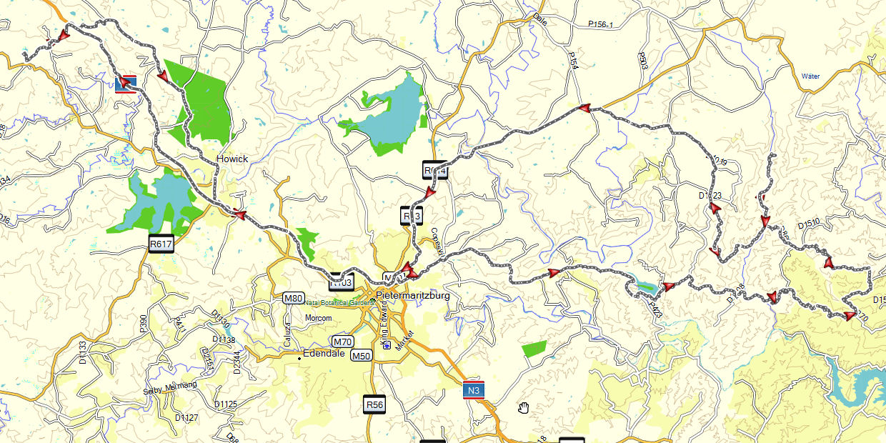
Day 11: Balgowan to Stutterheim. Worst. Road. Surface. Ever.
This was a long day in the saddle. After saying goodbyes, and picking up laundry, I left Beacon Vlei and headed South-West on the R617 just after Howick.
Turning south near Impendle and heading for Richmond on the P121. Easy going gravel, open farmland and rolling hills.

Just outside Richmond I turned right onto the P8-1 – the road that runs through Hella-Hella. This is quite a pleasant gravel pass, winding down to the Mkomzi river and steeply up the other side. Nothing really hectic but quite picturesque. About a 3.5/10 in the dry – this is apparently one of KZN’s top 10 rated passes. I wasn’t really that impressed.

Reaching the R612, it was tar through Underberg and then on to Matatiele over the rough dirt section where I first bent my rod on Geoff’s Lesotho trip. I was a bit more careful negotiating the potholes this time.

Back in the Eastern Cape now. Tar again all the way through Maclear, and on to Ugie. Turned left onto the DR02852 which took me on some lekker farm roads, and onto a sweet little pass between Qebe and Ngcobo.

Ncobo was packed – a monster traffic jam in a tiny town, and a massive queue to get petrol, but I had no choice. The R61 and then R352 are some of the worst roads I’ve been on. Not rocky – just bone-jarringly rough.
I finally made it through to Sutterheim where I was to spend the next 2 nights at the Manderson hotel. Strangely very quiet for a holiday period. But Stutterheim is probably not a place too many people go to on vacation.
Day 12: Hogsback is beautiful. Michel’s pass is horrid.
And the path I took through from Stutterheim was brilliant.
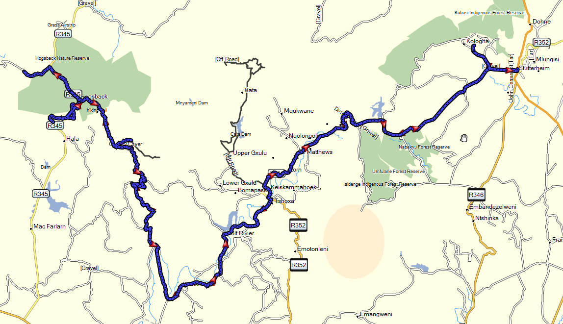

Starting off through the forests, the road winds around the Gubu dam, and down into Keiskammahoek. Turning right just after the small town, the road took me alongside the Sandile Dam and the Wolf River pass. Robbie Trygve hadn’t covered this route at the time – so my route is a little different, winding through the small settlements of Fort Cox, but ends up on the same pass.

The lower reaches are twee-spoor and a bit rocky, but travelling through lovely overgrown bush. Higher up it reaches forestry areas and the road is wider and smoother. A couple of waterfalls and dams, and the spectacular vista over the Amatole basin.

Coffee and scones were just the thing after such a wonderful ride. I’d thought to ride up to Michel’s pass and Katberg to have a looksee. I was a bit concerned about tackling them alone, both have a bit of a reputation of eating bikes.
I started off down Michel’s pass, saying to self “turn back if it gets rough” – but the pass itself was quite very disappointing to start. Very overgrown by invasive weeds, there is no view – and these weeds smelled like cat’s-piss. The path was ok for a while, but got rockier and looser – until I came to a spot that was well and truly washed away with large boulders. I walked up and down, thinking all the while – if I followed this line ….

Along came a Nissan up the pass in the opposite direction – and they spent the next 45 minutes struggling to get up and over this wretched place. I walked the line again, took a deep breath, got on my bike, and turned back to Hogsback. There will be other days.
I rode down the tar Hogsback pass, pretty and twisty – but it is only tar, and not a patch on the Wolf River pass- so I went back to Sutterheim the way I came.
Day 13: Stutterheim to Oudtshoorn. A meeja-person in Pearson
I’d originally thought to tackle Stutterheim to Home in one day. It would have been possible but I’d have not enjoyed it after such a great trip so far. So I’d called the previous day and booked at a B&B in Oudtshoorn instead.
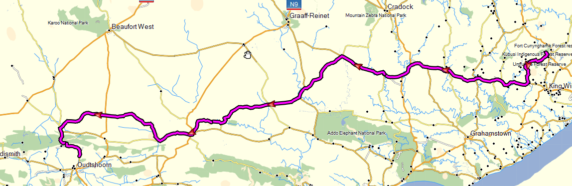
Apart from a start on gravel, today was mostly tar – R63 through Somerset East and on to Pearson and then down Jansenville on the R337.
As I crawled into Pearson looking for a coffee shop, I was waved down by another GS rider. It turned out to be none other than that famous TV show presenter: Henk Kotzee hiding from the crowds and disguised behind a beard. He was on his way to the out-laws in Cradock for the holidays.

No coffee in Pearson. Not much of anything really. So we wished each other a Merry Whatever and went off in different directions.
Coffee and lunch in Jansenville was welcome. It was starting to get a bit warm. The R337 turns into gravel after Jansenville, and finally becomes a really lovely little road twisting and turning as you approach Willowmore.
Willowmore through to Prince Albert on the P1728. Blasting along some marvellous gravel roads with the odd patch of sand. Suddenly it feels like the back is wallowing in really deep sand, look down and the rear pressure is 0. In 40 degree temperatures, these are the times where I am really, really, really happy that I have tubeless tires.

I tried first with the D-ring things, but I’m not patient enough to prepare the hole well enough. So they snap as I force them through the hole. Fortunately I carry both types, and the snotty-strings win the day. Back in the saddle, a quick cold-drink and cake in Prince Albert and then up and over the Swartberg Pass. Snotties holding wonderfully.
Die Fonteine B&B just outside Oudtshoorn is a nice place to stay.
Day 14: Home James, it’s Christmas eve. But take as much gravel as possible.
Robinson pass, and down some gravel through Herbertsdale and on to Riversdale.
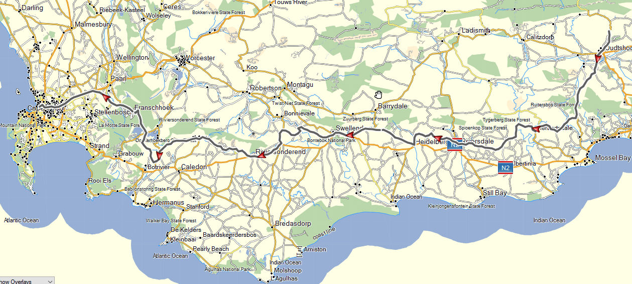
I turned too early, I had been intending to go up past Komatipoort dam, but ran alongside the railway line for a bit instead. Shrug. Let’s see where it goes.
It got a bit interesting, the GPS suggesting I take what looked to be an overgrown goat-track – but I muddled through and around to Heidelberg and then on through Suurbraak. Gravel around Bruintjies river and back down to Riviersonderend for a pie.
Through Greyton, Van der Stel pass and up over Franschoek pass.
Time for a quick wash and some groceries before Santa is supposed to arrive. Snotty still holding out – but the tyre is done anyway.

GPS Files: December-2015-public.zip (4.5Mb)
Google Photo Gallery: Eastern Cape and KwazuluNatal Dec 2015